

Amsterdam, defended against the Prussians (1787) – Cornelis van Baarsel + Dirk Meland Langeveld, 1790
€1.450


AMSTERDAM DEFENDED AGAINST THE PRUSSIANS, 1787
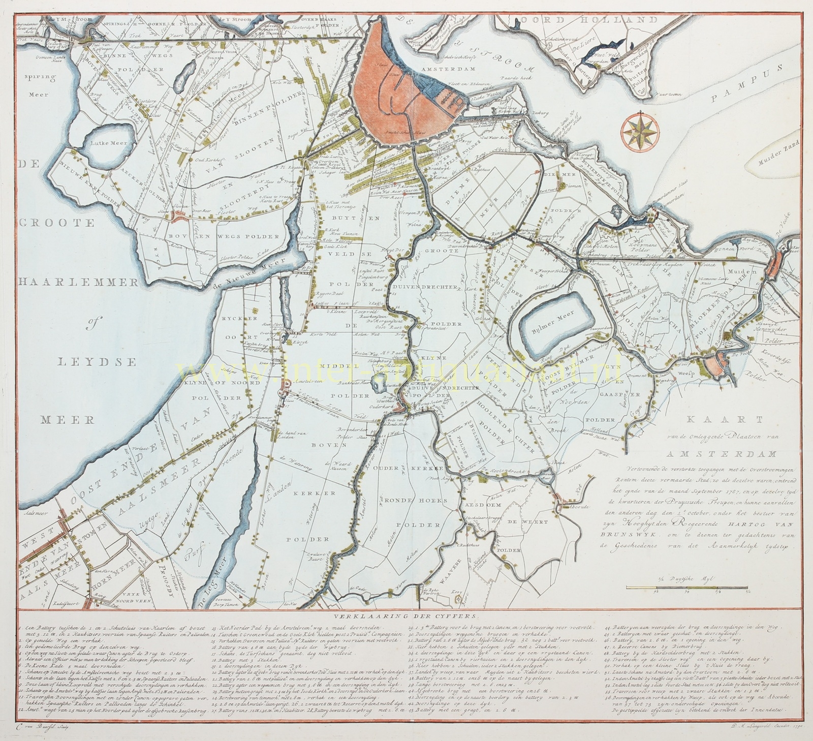
“Kaart van de omleggende plaatsen van Amsterdam …” (map of the surroundings of Amsterdam). Etching and engraving by Cornelis van Baarsel, published by Dirk Meland Langeveld in 1790. With original (?) hand-colouring. Size (plate mark) approx. 45.5 × 55.5 cm.
This map shows Amsterdam and the surrounding polder landscape during the Prussian invasion of 1787. It extends from Halfweg and the Haarlemmermeer in the west to Muiden and Weesp in the east, and from Amsterdam in the north to Aalsmeer, Uithoorn and Abcoude in the south. Roads, dykes and waterways form not only the topographical framework of the landscape, but also the defensive lines protecting the city.
In September 1787 Amsterdam was the principal remaining stronghold of the Patriots. The political struggle between Patriots and Orangists had reached its climax that year. On 28 June Princess Wilhelmina of Prussia, wife of stadtholder William V, had been stopped at Goejanverwellesluis by a Patriot Free Corps. Her brother, King Frederick William II of Prussia, demanded satisfaction and sent an army into the Dutch Republic in September. While Patriot resistance elsewhere quickly collapsed, the defence ultimately concentrated around Amsterdam.
The flat, waterlogged landscape surrounding the capital was deliberately employed as a means of defence. Large areas of the polders were inundated. A dotted line on the map marks the perimeter of the flooded area; numbers 57 to 73 indicate the individual openings through which the water was let in. This left primarily the higher roads and dykes as possible avenues of attack. These approaches were therefore blocked with artillery, sconces and other obstacles. The principle was the same as that employed in later Dutch water defence lines: the enemy was forced to advance along a limited number of narrow approaches.
The extensive “Verklaaring der Cyfers” (“Explanation of the Numbers”) below the map records this defensive system in detail. At Halfweg, between the two Haarlemmer sluices, stood an artillery battery with three twelve-pounder cannon and two howitzers, protected by chevaux de frise and palisades. A barricade of felled trees and a dismantled bridge obstructed the road, while heavy artillery was positioned behind a bridge near Osdorp. According to the legend, the Koenenkade had been cut through in six places.
The approaches from the south were likewise heavily fortified. Along the Amstelveenseweg and near the inn Het Kalfje were further sconces, batteries, cannon and barricades. Roads and dykes had been cut through at numerous points or blocked with verhakken. The legend also records traverses, excavated pits, removed bridges and breastworks. At Bovenkerk a battery with two twelve-pounders stood behind a demolished bridge; elsewhere, further batteries were positioned behind removed bridges and breached dykes.
The same defensive measures can be followed along the River Amstel and around Ouderkerk, Duivendrecht, Diemen, Weesp and Muiden. Cannon commanded bridges and dykes, breastworks protected the approaches and bridges had been demolished at several points. At Weesp a battery was positioned from which Muiden was bombarded with two howitzers.
Particularly remarkable were the floating batteries. At Het Kalfje the map shows a “vlotte Battery” (no. 52), consisting of five flat-bottomed barges, each carrying two guns. Closer to the city lay another such battery, while a third was under construction near the Overtoom. The last fixed sconce before Amsterdam was likewise situated at the Overtoom and armed with two six-pounders. The defences were therefore not confined to roads and dykes: the waterways too were closed off by artillery.
On 1 October 1787 the Prussian troops under the Duke of Brunswick launched their attack. Fighting concentrated, among other places, around Amstelveen, Ouderkerk and the eastern approaches to the city. At Amstelveen the Patriot positions were subjected to prolonged bombardment; by late morning the defenders there were forced to withdraw. Later that day Ouderkerk also came under heavy pressure.
The elaborate defensive works were able to delay the Prussian advance, but ultimately could not save Amsterdam. The city abandoned its resistance and on 10 October the capitulation was signed; Prussian troops subsequently occupied the Leidsepoort. Patriot rule in Amsterdam thereby came to an end and the authority of stadtholder William V was restored.
Van Baarsel’s map appeared three years later and was expressly intended, as its title states, “ter gedachtenis van de Geschiedenis van dit zo aanmerkelyk tydstip” — “to serve as a memorial to the history of this remarkable moment in time.” The combination of the meticulously drawn landscape and the extensive legend makes it more than an ordinary map of Amsterdam and its surroundings: it forms a detailed visual record of the way in which roads, dykes, bridges, waterways and polders were transformed into defensive works in 1787.
Price: Euro 1.450,-
