

Delfland – Nicolaas and Jacob Cruquius, 1712
€2.150
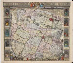
MASTERPIECE OF DUTCH CARTOGRAPHY: THE CRUQUIUS MAP OF DELFLAND, 1712
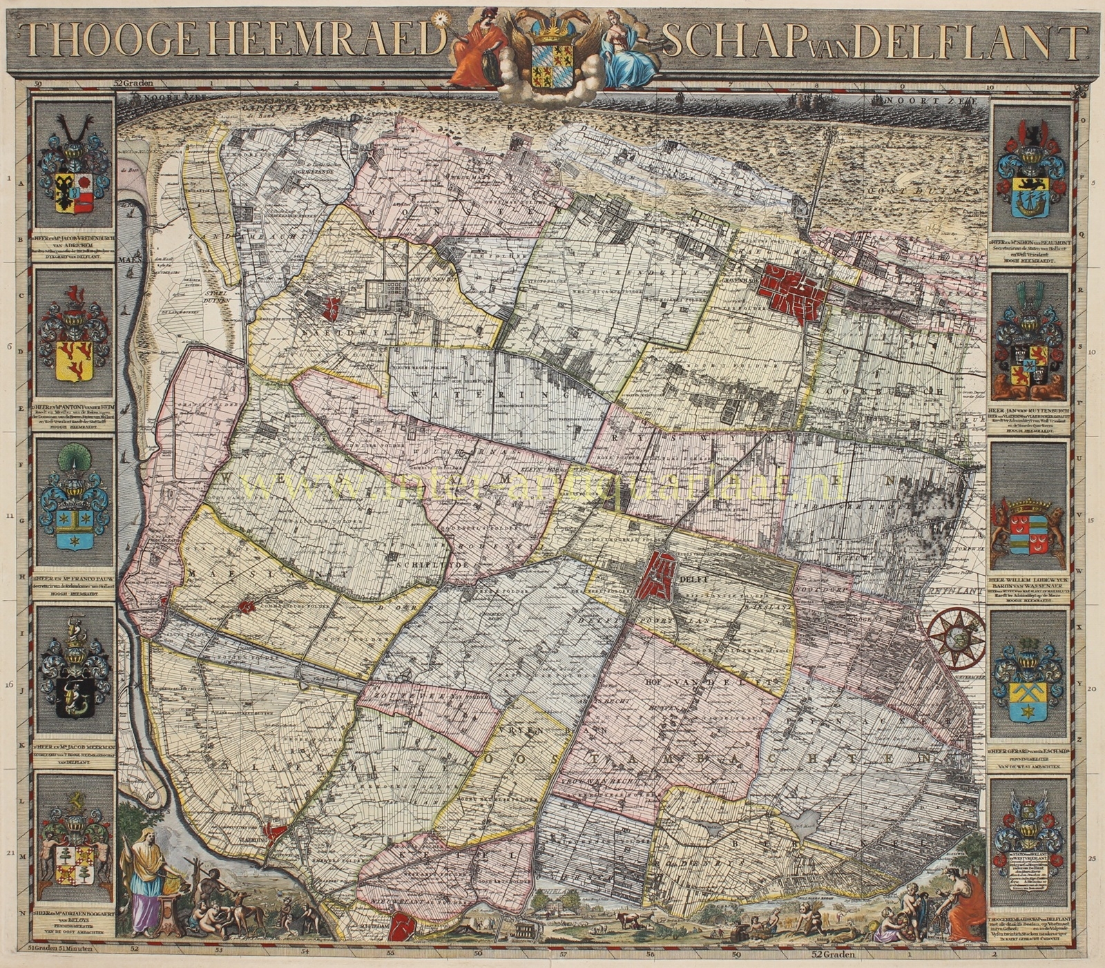
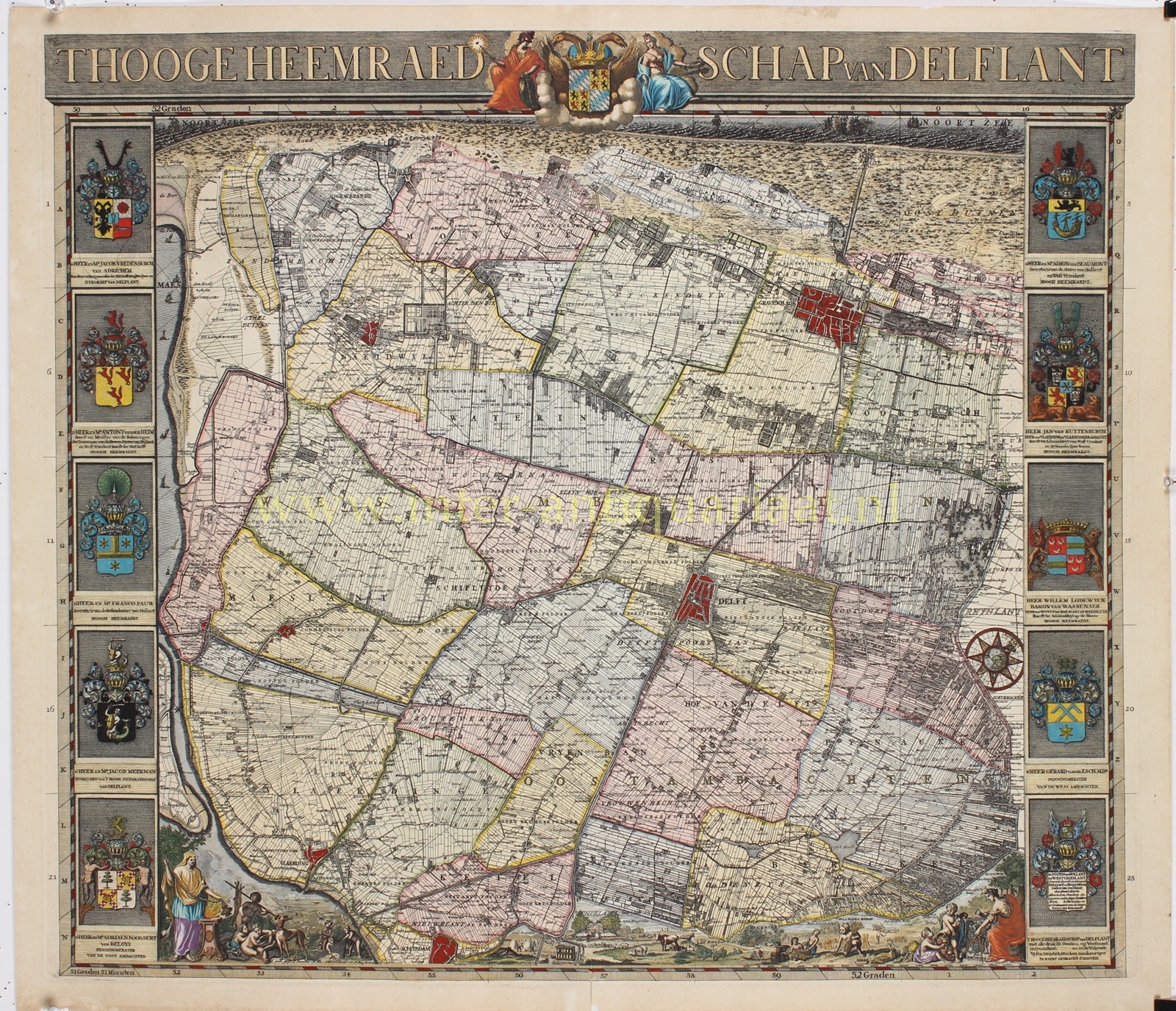
“‘T Hooge Heemraedschap van Delflant”, etching and engraving based on the surveys of the land surveyors Nicolaas and Jacob Cruquius, published by the Hoogheemraadschap van Delfland (Delfland Water Board) in 1712. Reduced overview map accompanying the celebrated 25-sheet wall map of Delfland. The map was engraved by Luggert van Anse, Thomas Doesburgh, Jacobus and Johannes Deur, and Pieter Sluyter. The elaborate ornamentation was based on designs by Arnold Houbraken; Pieter Haringh designed the coats of arms. With original hand colouring. Size approx. 52 × 58.5 cm.
This map presents the entire territory administered by the Hoogheemraadschap van Delfland at a glance and in exceptional detail. It is not oriented with north at the top in the modern manner: north lies towards the upper right, placing the North Sea along the upper edge and the River Maas to the left. The overview map is an accurate reduction of the large-scale map and was also intended as a key for assembling the separate sheets into a single wall map.
At the centre is the crowned coat of arms of the Hoogheemraadschap van Delfland, flanked by allegorical figures. Along both sides are the elaborately rendered arms of the dike reeve, the high water-board officials, the secretary and the treasurers. At the bottom, figures, animals and attributes associated with agriculture, hunting and fishing enliven the composition. At lower right, a woman holding a pair of dividers and the Cruquius family coat of arms refer to the art of surveying.
The map was the result of an ambitious project. In 1701, the Hoogheemraadschap van Delfland commissioned Nicolaas and Jacob Cruquius to survey and map its entire administrative territory anew. Using surveyor’s chains, they measured the landscape. Jacob died in 1706, after which Nicolaas continued the extensive undertaking. Ultimately, the map was transferred to 25 copperplates, which together formed a monumental wall map measuring approximately 230 × 280 cm. The project was completed in 1712.
The result ranks among the most important achievements of early eighteenth-century Dutch surveying. The map records not only towns and villages, but virtually the entire organisation of the landscape: ditches, canals, hydraulic works, roads, paths, individual plots, buildings, polders and administrative districts. It is precisely this systematic recording that continues to make the Cruquius map an important source for the study of Delfland’s historic landscape.
The undertaking cost the Hoogheemraadschap approximately 20,000 guilders, an enormous sum equivalent to more than 60 years’ wages for a skilled worker.
The Hoogheemraadschap van Delfland was an overarching water authority encompassing numerous smaller water boards. These bodies retained a degree of autonomy, but either fell under Rijnland or functioned as subordinate water boards and were heavily dependent on Delfland.
Prijs: Euro 2.150,- (incl lijst)
