

Africa – Willem + Joan Blaeu, c. 1640
€2.950


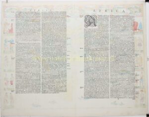

BLAEU’S FAMOUS MAP OF AFRICA
“Africae nova descriptio”, copper engraving published in Amsterdam by Willem Jansz. and Joan Blaeu, ca. 1640. Coloured by a later hand. Verso: German text. Size: 41 × 55.5 cm.
This is one of the most recognisable and decorative maps of the continent from the seventeenth century.
The outlines of the continent reflect the influence of the Portuguese and Dutch voyages of discovery around Africa to Asia. When Blaeu produced this map, the Dutch had not yet established themselves at the Cape; the names around the Cape of Good Hope therefore still refer chiefly to its maritime role as an anchorage and place of refreshment for ships on the route to the East.
Along the top of the map the principal African cities are depicted: Tangier, Ceuta, Algiers, Tunis, Alexandria, Cairo, the Island of Mozambique, Fort St. George on the Gold Coast, and Canaria in the Canary Islands. The left and right borders show a variety of indigenous dress: Moroccans, Senegalese, traders from Guinea, Congolese, Egyptians, Abyssinians, Mozambicans, the king of Madagascar, and inhabitants of the Cape of Good Hope.
These figures are not intended as neutral ethnographic documentation, but as European representations of African peoples and cultures. They reflect the seventeenth-century atlas reader’s fascination with dress, appearance, status, and supposed cultural difference.
The text on the reverse of the map offers an early seventeenth-century picture of Africa, in which classical geography, biblical and ancient tradition, travel accounts, and early modern cartography run together.
The continent is presented as a great peninsula, surrounded on almost every side by water: to the north by the Mediterranean Sea, to the west by the Atlantic Ocean, to the east by the Red Sea and the Arabian Sea, and to the south by the great ocean. Only at the Isthmus of Suez is Africa joined to Asia. The text compares Africa with Europe: the continent is larger, but more sparsely populated. This is explained by the heat, the vast deserts, the inaccessibility of large parts of the interior, and the presence of venomous animals.
The natural riches and wonders of Africa are discussed. The fertility of certain regions, especially in Mauretania and Barbary, is praised. There, the fields are said to yield abundant harvests, and trees, plants, and fruits to grow exceptionally well. At the same time Africa is portrayed as a continent of contrasts: fertile coastlands and river regions set against dry interiors, rugged mountains, and near-impenetrable deserts. Among the animals named are elephants, lions, buffaloes, panthers, rhinoceroses, apes, wild asses, ostriches, and countless kinds of serpents. In this the text aligns with the traditional European image of Africa as a continent of abundance, danger, and exotic nature.
Africa is then divided geographically. First come the old Roman and Ptolemaic provinces, such as Africa Proconsularis, Numidia, Mauretania, Cyrenaica, Marmarica, Libya, and Egypt. Next follows the division of the Moorish explorer Leo Africanus, who divides Africa into larger zones: Barbary, the region of the deserts, the “Land of the Blacks” or Nigritia, Egypt, Abyssinia, and the interior. Numerous kingdoms and territories are named, among them Morocco, Fez, Tunis, Barca, Tripoli, Biledulgerid, Gaoga, Oualata, Guinea, the Mali region, Timbuktu, Bornu, Nubia, Benin, and many others.
Egypt is given a place of its own. It is described as an elongated land along the Nile, bounded by the Mediterranean Sea, Libya, Nubia, and the Red Sea. The surrounding deserts, the Nile, and the connection with Asia are also mentioned. Abyssinia is presented as the great Christian empire of the legendary Prester John. It is said to extend from the vicinity of Nubia and the Red Sea deep into the interior, and according to the text it comprises various kingdoms and landscapes.
The southern and eastern part of Africa is described as the part that the ancient writers scarcely knew. The text names, among others, Zanzibar, Ajan, Adal, Mogadishu, Malindi, Mombasa, Kilwa, Mozambique, Mutapa (“Monomotapa”), Sofala, Angola, and Congo. Here the history of European discovery also comes up: only after Vasco da Gama had rounded the Cape of Good Hope in 1497/1498 and opened the sea route to India did this part of Africa become better known to Europeans. The text emphasises that, from then on, Africa was no longer seen merely as a closed or half-known continent, but as part of the great shipping route to Asia.
An important geographical theme is the river system. The text names the Nile, the Niger, the Senegal, the Gambia, the Congo/Zaire, the Zambezi/Cuama, and the Limpopo. These rivers are presented as the great arteries of Africa, rising from lakes, mountains, and unknown interiors and bringing great fertility.
The mountains of Africa likewise receive ample attention. The Atlas is named as the most famous mountain, so high that its peaks are said to rise above the clouds; for this reason it was sometimes called the “pillar of heaven” in the classical tradition. The text describes the mountain as vast, inaccessible, cold on its highest peaks, and rich in forests and springs. In addition, the Montes Lunae, the Mountains of the Moon, are mentioned, which in classical geography were linked to the sources of the Nile. Silver mountains in Angola and other ranges are also discussed.
At the end, the text treats the islands around Africa. In the Atlantic Ocean it names, among others, Porto Santo, Madeira, the Canary Islands, and the Cape Verde Islands. Madeira, according to the text, owes its name to the many trees that grew there. The Canary Islands are connected with the Fortunatae Insulae of antiquity. The islands of São Tomé and Príncipe in the Gulf of Guinea are mentioned as well. Finally, the great island of São Lourenço, today Madagascar, is discussed.
The text thus corresponds precisely to the map itself: a mixture of new European maritime knowledge, ancient learning, and the early modern fascination with Africa as a rich, dangerous, and still only partly known continent.
Willem Jansz. Blaeu (1571–1638) was among the foremost mapmakers of the seventeenth century. His position in Amsterdam, his ties to the international book and map trade, and his role as cartographer to the Dutch East India Company gave him access to recent geographical information. At the same time, his map of Africa remained indebted to older sources.
From 1608 he dominated the market for wall maps and maritime atlases, and in 1630 he produced his atlas of the world. These atlases were continued by his sons Joan (ca. 1599–1673) and Cornelis (1610–1644) and culminated in the monumental Atlas Maior of 1662 in eleven volumes, published by Joan Blaeu.
Price: Euro 2.950,-
