

Indonesia, Bangka Strait – Laurie and Whittle, 1796
€495
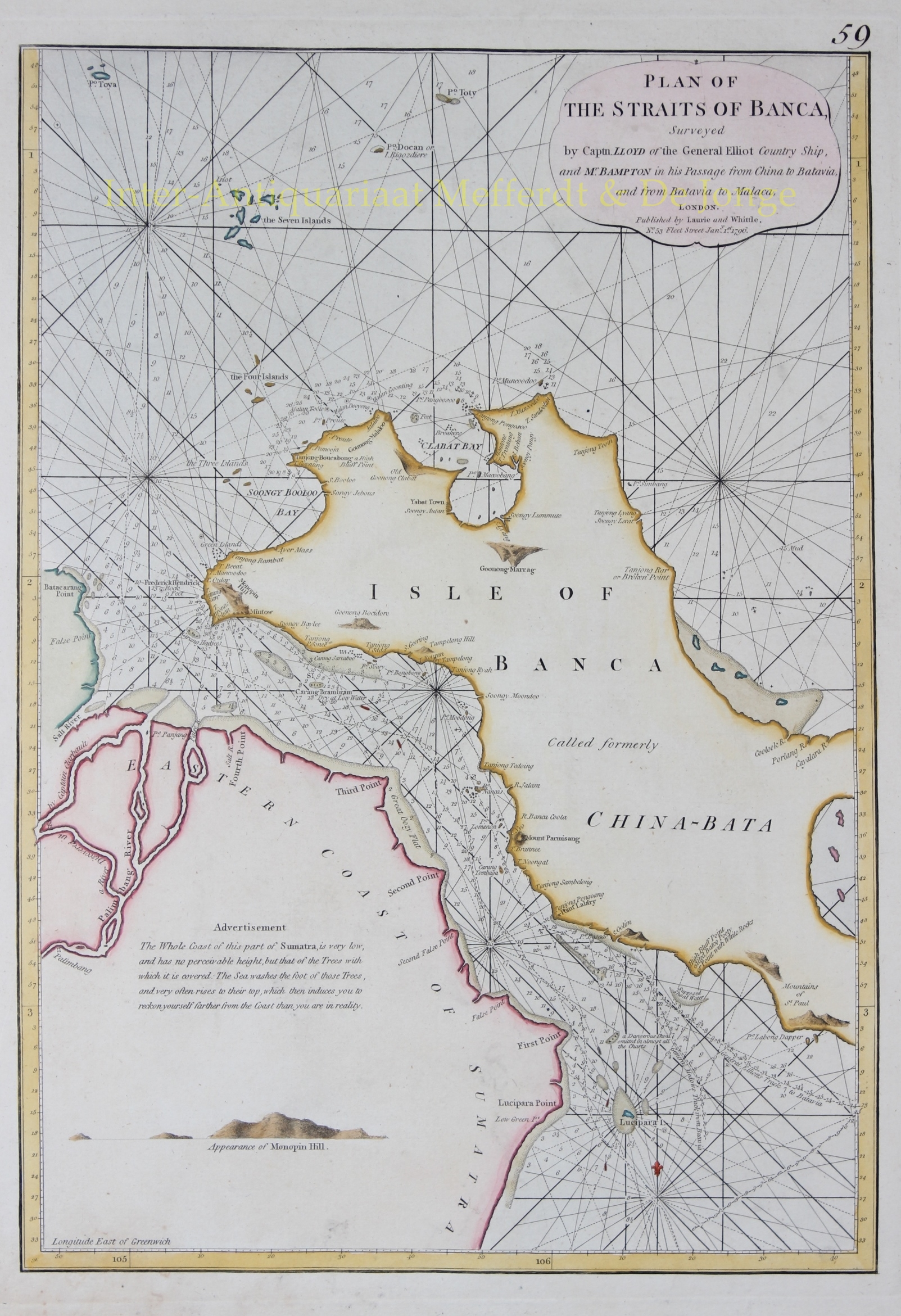
NAUTICAL CHART OF THE BANGKA STRAIT BETWEEN SUMATRA AND BANGKA, 1796
“Plan of the Straits of Banca”, copper engraving published in London by Robert Laurie and James Whittle on 1 January 1796, and included in their nautical atlas The East-India Pilot, or Oriental Navigator. Coloured by a later hand. Size: approx. 47.5 × 33 cm.
This detailed eighteenth-century nautical chart depicts the Bangka Strait, separating Bangka Island from the eastern coast of Sumatra. The strait formed an important link in the shipping routes between the Indian Ocean, Batavia, the Strait of Malacca and China. Navigation, however, was particularly challenging because of the numerous islands, sandbanks and treacherous shoals. Accurate hydrographic information was therefore essential for merchant shipping.
Bangka was itself an important trading region. At the time, the island belonged to the Sultanate of Palembang and had developed into a major centre of tin mining during the eighteenth century. Much of its production was traded through the Dutch East India Company (VOC), although British traders and Chinese merchants were also active in the region. The tin trade contributed considerably to the economic importance of Bangka and its surrounding waters.
The chart depicts almost the entire island of Bangka, formerly also known as China-Bata, and the opposite coast of Sumatra, including river mouths, headlands, bays and numerous smaller islands. The surrounding waters are marked with hundreds of depth soundings, sandbanks, reefs, anchorages and other navigational information. A dense network of rhumb lines enabled mariners to plot their courses and navigate their ships through the narrow waterways.
Particularly interesting are the detailed warnings and sailing directions provided for mariners. The chart identifies a dangerous shoal which, according to its compiler, had been omitted from almost all other nautical charts. A separate warning concerns the low-lying eastern coast of Sumatra. This coastline was extremely difficult to distinguish from the sea, as virtually no elevated landmarks rose above the vegetation. Furthermore, the sea could wash up to the tops of the coastal trees, creating the misleading impression that ships were farther from the shore than they actually were.
At lower left is a coastal profile of Monopin Hill, present-day Bukit Menumbing, on the northwestern side of Bangka. This prominent hill served as an important navigational landmark for ships approaching the Bangka Strait. Centuries earlier, Asian mariners had already used this distinctive elevation to establish their position and locate the approach to the Musi River leading to Palembang.
The chart is based on surveys conducted by Captain Lloyd, commander of the British merchant vessel General Elliot, supplemented by observations made by Bampton during his voyages from China to Batavia and from Batavia to Malacca. The General Elliot was a so-called country ship, engaged in trade between Asian ports rather than the long-distance voyages between Europe and Asia undertaken by the large East Indiamen. Such vessels made important contributions to the hydrographic knowledge of the region, as their captains recorded navigable channels, water depths and maritime hazards during their trading voyages.
The potentially life-saving importance of such information is illustrated by an incident in 1789. While sailing through the Bangka Strait, Captain Lloyd learned that the British ship Vansittart, commanded by Captain Lestock Wilson, had struck a rock near the neighbouring island of Belitung. Lloyd sailed to the scene of the shipwreck aboard the General Elliot, accompanied by the Nonsuch. Although the Vansittart had already been lost, they managed to salvage a substantial part of her valuable cargo. The incident was later described by the celebrated British navigator William Bligh in his Voyage to the South Sea.
Price: Euro 495,-
