

Southeast Asia – Jan Huygen van Linschoten, 1595/1638
€17.500

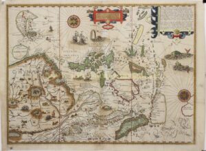
SEA CHART FROM THE FIRST PRINTED WORK WITH PRECISE SAILING INSTRUCTIONS FOR THE EAST INDIES, 1595/1638
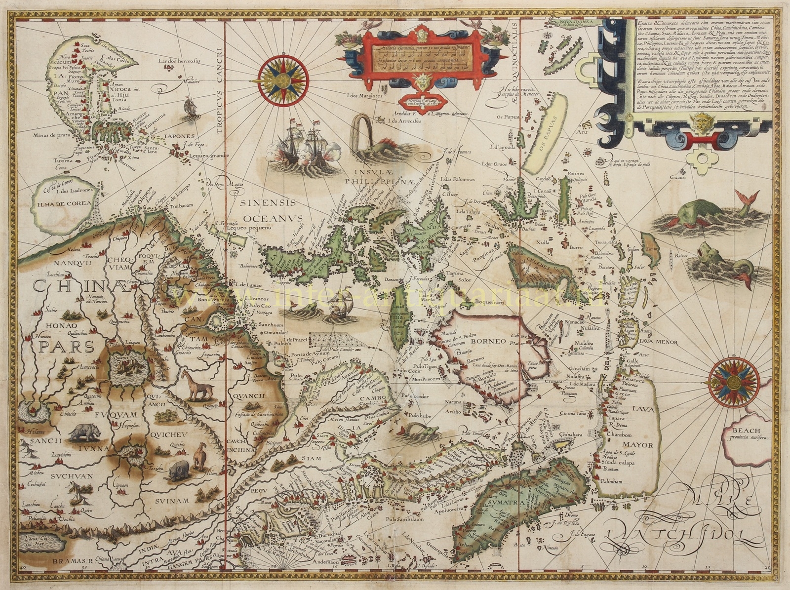
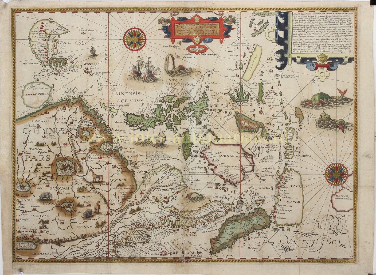
“Exacta & Accurata Delineatio cum Orarum Maritimarum tum etjam locorum terrestrium quae in Regionibus China, Cauchinchina, Camboja sive Champa, Syao, Malacca, Arracan & Pegu…” [Accurate depiction of the coasts and lands of China, Vietnam, Cambodia, Siam, Malacca, Arakan and Pegu, with the surrounding islands, cliffs, reefs, sandbanks, shoals and shallows…]. Copper engraving designed by Arnold Floris van Langren and engraved by his brother Hendrik Floris van Langren in 1595, for Jan Huygen van Linschoten. This example was published in Amsterdam by Evert Cloppenburgh in 1638, as part of the French edition of Van Linschoten’s famous “Itinerario“. Contemporary hand colouring. Approx. 38 × 53 cm.
This spectacular map ranks among the most important early printed maps of East and Southeast Asia. It covers a vast area: from present-day Myanmar and the Bay of Bengal, through Malacca, Sumatra, Java and Borneo to the Moluccas, the Philippines and New Guinea, and northwards as far as China, Korea and Japan. The map is unusually oriented with north to the left. Two large compass roses and a fine network of rhumb lines emphasise its origins as a sea chart.
For much of the sixteenth century, the Portuguese enjoyed a considerable advantage in their knowledge of the sea routes to and within Asia. The cartographer Jan Huygen van Linschoten (1563–1611) left the Netherlands for Spain in 1579 and in 1583 secured passage to India as secretary to Vicente da Fonseca, the newly appointed Portuguese Archbishop of Goa. This gave him access to secret information, including portolan charts of the East Indies that had been carefully guarded for more than a century. With little regard for the trust placed in him, Van Linschoten began meticulously copying these maps. After returning to the Netherlands, he compiled an account of his travels in 1595, illustrated with prints based on his own drawings and maps incorporating information obtained from the Portuguese. His Itinerario, published in 1596, was the first printed work to include precise sailing instructions for the East Indies. It enabled Dutch merchants to circumvent the Portuguese stranglehold on trade with the East. The work was of such economic importance that it was supplied to every ship sailing from Holland to the Indies and soon became known as the navigator’s vade mecum for the Eastern seas.
The map itself also drew on the cartographic work of Petrus Plancius, who had access to Portuguese manuscripts by, among others, Bartolomeu Lasso. The depiction of Japan reflects the work of the Portuguese cartographer Fernão Vaz Dourado, while the interior of China derives from Abraham Ortelius’s map of China, which in turn was based on information supplied by the Portuguese cartographer Luís Jorge de Barbuda. The map thus represents a synthesis of the best geographical knowledge available in the Netherlands during the 1590s.
At the same time, it vividly reveals the limits of European geographical knowledge. Korea is depicted as a large, almost circular island. Japan has the characteristic shape sometimes compared to a shrimp. The southern coast of Java was still largely unknown and is consequently only imperfectly represented, while Borneo, Celebes and New Guinea likewise have outlines that differ considerably from their actual forms. By contrast, the Philippines are shown in remarkable detail and with a degree of geographical sophistication that was advanced for the period.
At the southernmost tip of the Malay Peninsula appears “Sincapura”, an early European occurrence of the name Singapore. At lower right is the enigmatic “Beach provincia aurifera” [gold-rich province of Beach]. This mythical territory entered European cartography through the travel account of Marco Polo and was gradually displaced towards the unknown Terra Australis, roughly in the region where Australia would later appear on European maps.
The practical function of the map is combined with lavish decoration. In the interior of China, elephants, rhinoceroses and other exotic animals are depicted; large sailing vessels cross the seas, two of them exchanging cannon fire. Imaginative sea monsters, two compass roses and elegant Renaissance cartouches further enliven the composition. The map is therefore a striking combination of navigation, geographical knowledge and the sixteenth-century European imagination of Asia.
Van Linschoten’s work played an important role in eroding the Portuguese advantage in knowledge of the sea routes to Asia. The Itinerario became an important practical source for Dutch ventures to the East, while the map remained an authoritative representation of the region for many years. The original copperplate of 1595 was therefore reused for several later editions. This example belongs to the French edition of 1638; the engraved date 1595 on the plate remained unchanged.
This Van Linschoten Southeast Asia map of 1595 ranks among the most important early printed maps of East and Southeast Asia.
Price: Euro 17.500,- (incl. frame)
