

Livonia and Estonia – Otto Friedrich von Pistohlkors, 1774
€1.450

FIRST BALTIC GERMAN MAP OF LIVONIA AND ESTONIA, 1774
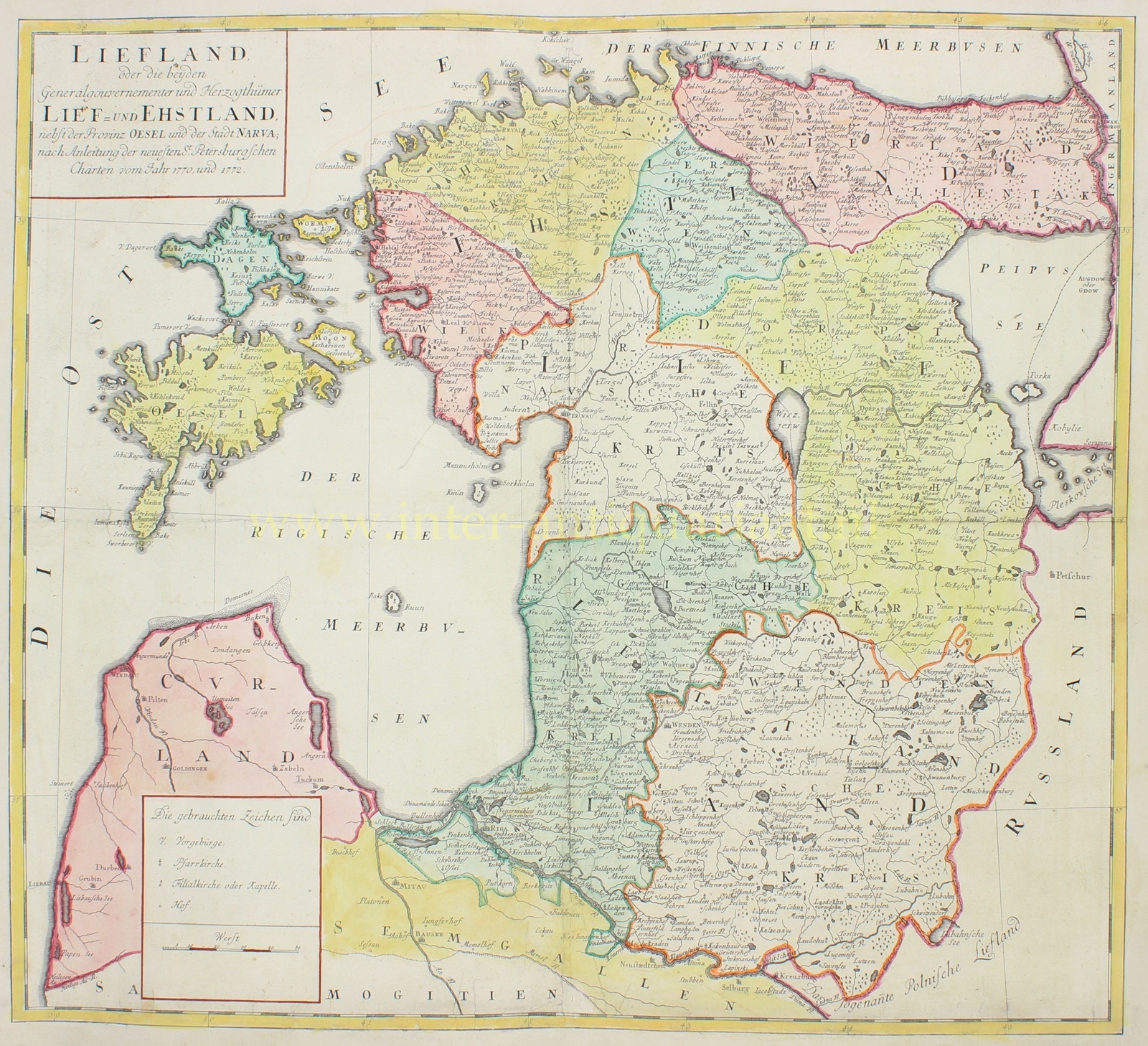
“Liefland, oder die beyden Generalgouvernementer und Herzogthümer Lief- und Ehstland, nebst der Provinz Oesel und der Stadt Narva” [Livonia, or the two governorates and duchies of Livonia and Estonia, together with the province of Ösel and the city of Narva]. Copper engraving after the design by Otto Friedrich von Pistohlkors, published in Riga by Johann Friedrich Hartknoch in 1774 as a map supplement to the first volume of August Wilhelm Hupel’s “Topographische Nachrichten von Lief- und Ehstland.” Later hand-coloured. Dimensions 53.7 × 59.8 cm.
This exceptionally detailed map shows the territory of present-day Estonia and a large part of Latvia in the second half of the eighteenth century. The Gulf of Finland lies along the northern edge, with the Russian border and Lake Peipus to the east, while the islands of Ösel (Saaremaa), Dago (Hiiumaa) and Worms (Vormsi) are shown prominently to the west. Among the towns and cities that can readily be identified are Reval (Tallinn), Narva, Dorpat (Tartu), Pernau (Pärnu), Riga and Arensburg (Kuressaare).
Estonia is divided into, among others, Harrien, Wierland, Jerwen and Wiek; to the south lie the districts of the Livonian governorate. The map is densely filled with towns, villages, estates, churches, rivers, lakes, forests and other geographical detail. A separate panel at lower left explains the map symbols and includes a scale in versts.
Otto Friedrich von Pistohlkors (1754–1831) based his map on the most recent official Russian surveys by Jacob Friedrich Schmidt: his map of the Governorate of Estonia of 1770 and that of the Governorate of Livonia of 1772. In doing so, the map broke with many older Western European maps of the Baltic region, which were often still based on seventeenth-century models. It was thus the first map published by Baltic Germans to depict the whole of present-day Estonia, and was considerably more accurate than its predecessors.
The map appeared in the first volume of August Wilhelm Hupel’s “Topographische Nachrichten von Lief- und Ehstland.” Hupel, a Baltic German clergyman and one of the leading representatives of the Enlightenment in the Baltic provinces, gathered information on the geography, history, population, economy and administration of Estonia and Livonia with the assistance of more than one hundred correspondents. His three-volume work, published between 1774 and 1782, became a fundamental eighteenth-century description of the region.
Estonia and Livonia had been governorates of the Russian Empire since the Treaty of Nystad of 1721, but retained many of their own Baltic German administrative and social structures. The German place names and terminology used on the map reflect the distinctive position occupied by the Baltic provinces within the empire.
Price: Euro 1.450,-
RESERVED
