

Dover – Soviet map, 1972
€450
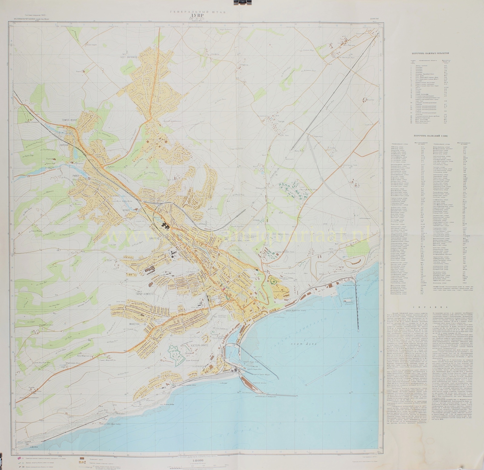
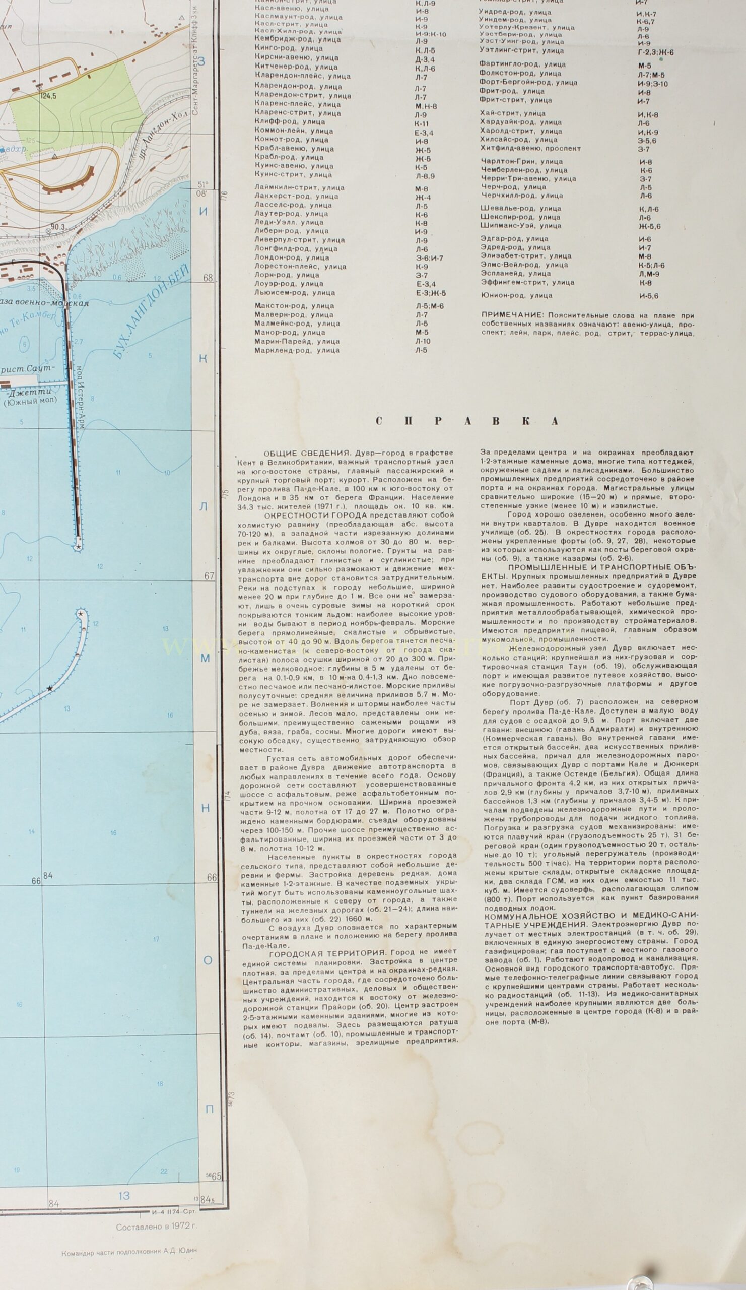

SECRET SOVIET MILITARY MAP OF DOVER, 1972
“ДУВР” [Dover], colour offset print, made in 1972 by the Military Topographic Directorate of the General Staff of the Soviet Union. Size: 84 × 87.5 cm.
This map forms part of the secret Soviet military cartography of the Cold War. From the 1940s onwards, the Military Topographic Directorate of the General Staff systematically mapped cities, harbours, industrial areas, and transport nodes throughout the world. These maps served operational planning, logistical analysis, and strategic orientation. They recorded not only streets, buildings, and waterways, but also terrain, transport capacity, industry, energy supply, communications, and military installations.
Dover therefore possessed obvious strategic importance. The town lay on the Strait of Dover, approximately 100 kilometres south-east of London and only 35 kilometres from the French coast. In 1971, Dover had a population of approximately 34,300 and covered an area of some 10 km². Its importance derived not from its size, but from its position as a major passenger port, commercial harbour, and transport link between Great Britain and continental Europe.
The map encompasses not only the town itself, but also its harbour, coastline, railway lines, approach roads, and hilly surroundings. The ground consisted largely of clay and loam soils, which became heavily waterlogged after rain and impeded movement away from the roads. Hedges, enclosures, scattered woodland, and low hills further restricted visibility and cross-country movement.
The coast formed a strategic feature in its own right. Along the Strait of Dover stood steep, in places rocky, chalk cliffs rising from 40 to 90 metres, interrupted by narrow stretches of beach and shingle. Tidal conditions, the seabed, depths offshore, and access to the harbour determined the maritime approach. Dover thus functioned not merely as a town, but as a landing point, harbour complex, and gateway to England.
The harbour formed the focal point of the map. Dover possessed an outer harbour, Admiralty Harbour, and an inner harbour, the Commercial Harbour.
Within the harbour lay open and artificial basins, quays for rail ferries to Calais, Dunkirk, and Ostend, as well as extensive storage and transhipment facilities. The map records railway connections, pipelines for liquid fuels, cranes, sheds, open storage grounds, cold stores, grain storage, and fuel depots. The number of cranes, depths alongside the quays, and the capacity of the dry dock were recorded in detail. The port could also serve as a submarine base. Harbour installations, rail-ferry connections, and coastguard operations together formed a strategic complex at the narrowest crossing of the Channel.
Dover had several railway stations. The principal installation was the Dover Town goods and marshalling station, directly connected to the harbour and its transhipment yards. Railway tunnels and former coal mines north of the town could provide underground shelter. The road network around Dover consisted of main roads with asphalt or asphalt-concrete surfaces, suitable for motor traffic throughout the year. Main roads were broad and straight; secondary roads were narrower and less well surfaced.
The town centre lay east of Dover Priory station. Dover had no uniform urban plan. The centre contained dense, largely continuous development of two- to five-storey stone buildings, many with basements. The town hall, post office, offices of transport and commercial firms, shops, and public institutions stood here. Beyond the centre, lower stone houses predominated, often of cottage type, with gardens and small plots. Most industrial enterprises lay around the harbour and on the outskirts.
The map also records the military presence in and around Dover. A military school operated in the town, while several fortified forts stood in the surrounding area, some serving as coastguard posts, alongside barracks and other military sites. Dover’s strategic significance in 1972 rested primarily on its harbour, railway lines, ferry connections, coastguard facilities, and exceptional proximity to France. The older fortifications nonetheless remained identifiable military sites within this wider defensive landscape.
Dover’s industrial base was modest in comparison with that of larger British cities. Shipbuilding, ship repair, and the manufacture of marine equipment formed the principal sectors. Paper manufacture, metalworking, chemical industry, building materials, and food processing, including flour milling, were also present. The town depended above all on its maritime and logistical role.
Energy supply, communications, and healthcare also formed part of the survey. Dover received electricity from local generating stations connected to the national grid. The town had gas supply, mains water, sewerage, bus services, several radio stations, and direct telephone and telegraph connections with the country’s principal cities.
The map therefore offers far more than a town plan. It provides a broad inventory of urban infrastructure and its possible significance in a crisis.
Dover emerges as a strategic node at the entrance to the Channel. The combination of the exceptionally detailed map, the list of important objects, the street-name index, and the extensive Spravka [explanatory note] makes this sheet a remarkable document of Cold War military geography.
Only after the dissolution of the Soviet Union in 1991 did the scale of this global cartographic programme become clear. Despite efforts to destroy the material, many maps reached the West. They are now valued as rare and compelling documents from a period in which European cities and ports were analysed and recorded not only in civil, but also in military-strategic terms.
Price: Euro 450,-
