

World map – Pieter van den Keere / Johannes Janssonius, (1608) 1630/1631
€11.500
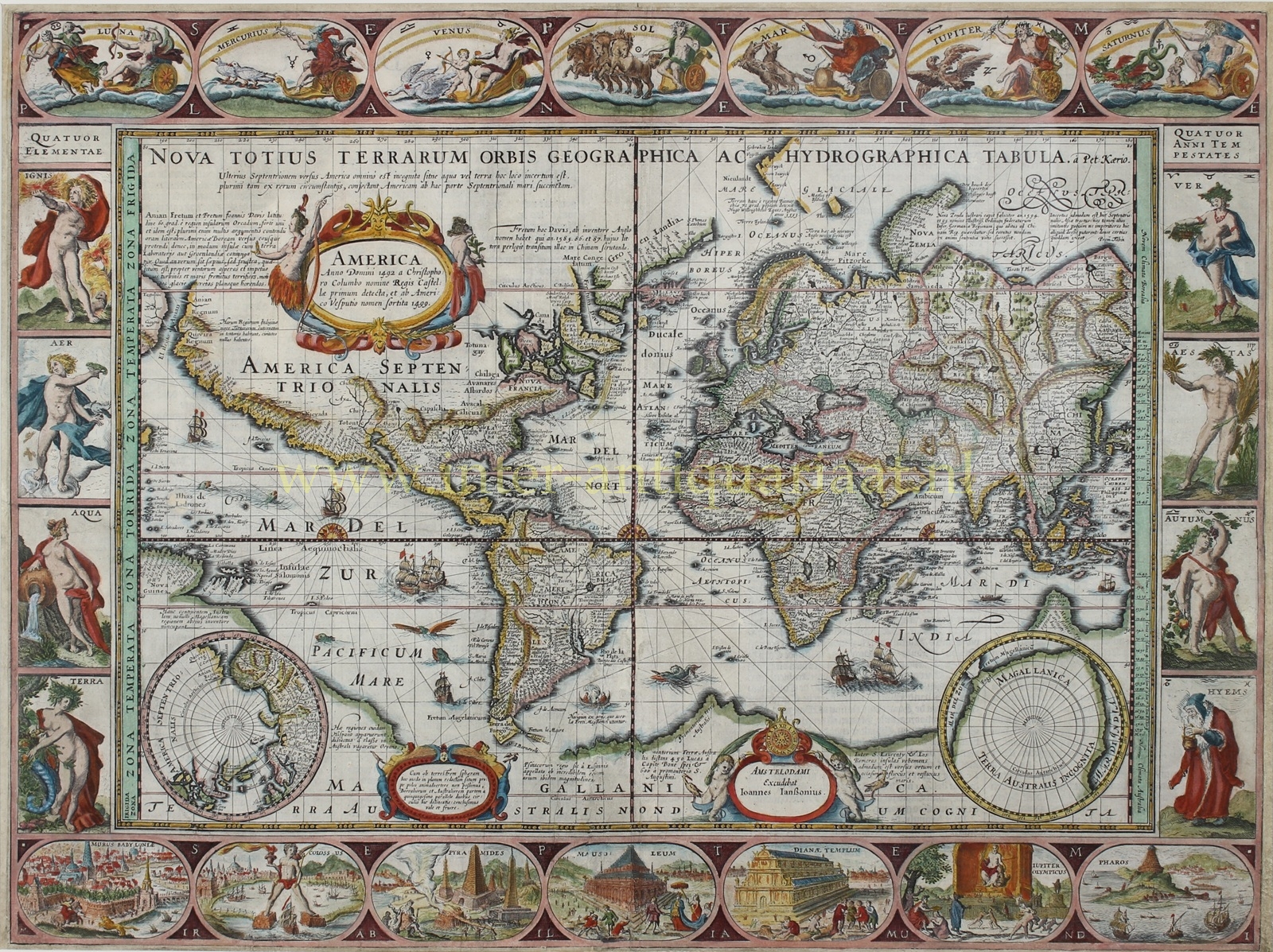
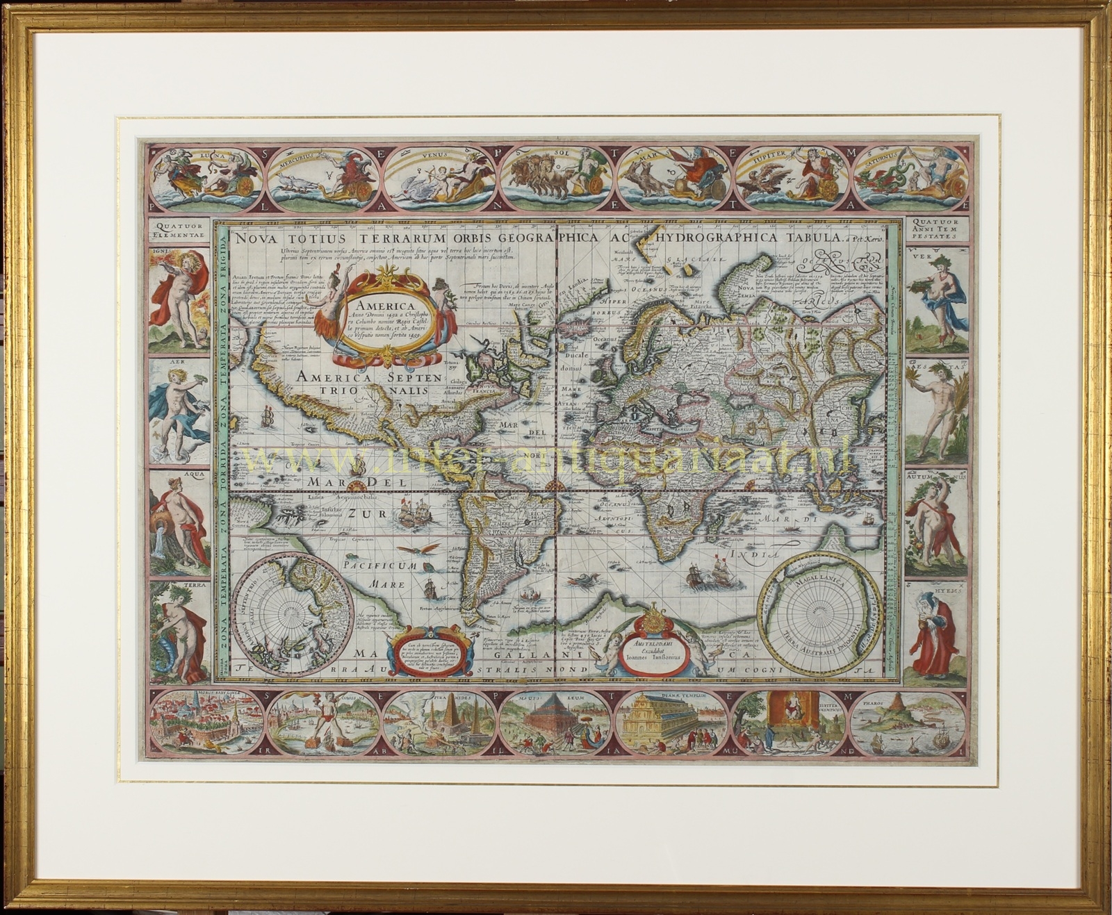


“Nova Totius Terrarum Orbis Geographica ac Hydrographica Tabula” [New geographical and hydrographical map of the whole world.] Copper engraving made by Pieter van den Keere (also known as Petrus Kaerius) in 1608 and published in the “Atlantis Maioris Appendix” by Johannes Janssonius, 1630/1631. Coloured by a later hand. Size: 40 × 53 cm.
This world map is regarded as one of the highlights of Dutch cartography of the Golden Age. The map is clearly based on the world map of Willem Jansz. Blaeu of 1606, but Van den Keere added more explanatory texts, especially concerning possible discoveries in the Arctic, the Antarctic, and the region of Australia.
The map contains several characteristic geographical hypotheses of the early seventeenth century. Thus the north-west coast of America is shown greatly elongated, an enormous and still largely enigmatic Southern Land (“Terra Australis”) is assumed, and only a narrow strait separates this southern continent from South America. New Guinea, too, is still incompletely rendered and appears to be connected to the unknown Southern Land.
Beside the large cartouche bearing the title “America” are extensive notes on the question of whether the legendary Strait of Anián (near present-day Alaska) and the Davis Strait might together have formed a north-western passage to Asia. Van den Keere writes: “Whether this is true has been repeatedly but vainly investigated, on account of the rough and violent whirlwinds, the terrifying roar of the sea, and the wholly dreadful icebergs.”
The map originally appeared in 1608. The Le Maire Strait, to the east of Tierra del Fuego, was added to the copper plate only after its discovery by Jacob Le Maire and Willem Schouten in 1616, presumably around 1621. The plate then came into the possession of Johannes Janssonius, who used the map only in a few early editions of his atlas. (Later the plate was extensively reworked and re-issued in the 1680s by Moses Pitt.)
The annotations make clear how Pieter van den Keere viewed the world: with particular attention to recent voyages of discovery and to the regions on the margins of the known world. Where Blaeu left areas blank, Van den Keere filled them with notes drawn from other sources. These include Spanish and Portuguese reports on the Pacific Ocean, but also more detailed information about English and Dutch expeditions in the Arctic.
Concerning Terra Australis, the following annotations appear, from left to right, among others:
“This southern landmass some call the Magellanic region, after its discoverer.”
“These regions are said to have appeared to ‘a certain Spaniard’ (possibly Jorge de Meneses) when, having become separated from the fleet, he wandered about this southern ocean.”
(The legendary) “Psittacorum Regio (Land of the Parrots) is so named by the Portuguese on account of the incredible size of those birds there.”
“Cape of the Southern Land, situated at a distance of 450 miles from the Cape of Good Hope and 600 leagues from Cape Saint Augustine (Brasil).”
“Between the islands of Madagascar and (the supposed) ‘Los Romeros’ there is a very strong ebb and flow of the sea, in an easterly and westerly direction.”
To the east of Tierra del Fuego, beside a small boat, is the text: “A vessel of hides, such as the inhabitants of the Strait of Magellan use.” This depiction is derived from the map of America by Jodocus Hondius of 1606.
To the north of the known America, according to Van den Keere, the region remained entirely unknown. It was not known whether there lay land or sea. Yet many supposed that America was surrounded on its northern side by a sea, a notion that accorded with the search for a north-western passage.
Concerning Nova Zembla it is recorded that in 1594 and 1595 it was successfully explored in the name of the States General of the Netherlands, in search of an approach to China. The result, however, had not yet met expectations.
With regard to North Asia, Van den Keere observes that this region was exceedingly uncertain. Nevertheless he had placed it on the map, following others, so that less experienced readers of the map would not think that something was missing here, until more reliable knowledge should become available.
In the west of North America there is a further ethnographic note: “The native inhabitants of these regions dwell, after the custom of the Tartars, in tents grouped together; cities they have none.”
The map is richly decorated. Van den Keere also included his personal signature: a clock with a skull at its centre, surrounded by flames.
The borders around the map are filled with allegorical representations. At the top are vignettes of the solar system as then known: Luna (the Moon), Mercury, Venus, Sol (the Sun), Mars, Jupiter, and Saturn. On the left are the four terrestrial elements: Ignis (fire), Aer (air), Aqua (water), and Terra (earth). On the right the four seasons are depicted: Ver (spring), Aestas (summer), Autumnus (autumn), and Hyems (winter). At the bottom are the Seven Wonders of the Ancient World: the Hanging Gardens of Babylon, the Colossus of Rhodes, the pyramids of Giza, the Mausoleum at Halicarnassus, the Temple of Diana at Ephesus, the statue of Zeus at Olympia, and the lighthouse of Alexandria.
Literature:
- Rodney Shirley, The Mapping of the World, no. 264;
- Günter Schilder, Monumenta Cartographica Neerlandica, VIII, Keere Appendix 13.1, pp. 517–518.
Price: Euro 11.500,- (incl. frame)
