

IMPRESSIVE 18TH-CENTURY WALL MAP OF ZEELAND
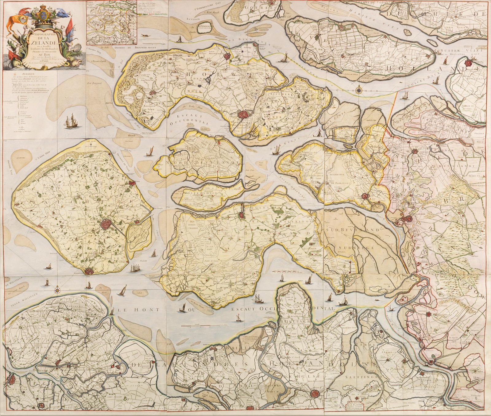
“Topographie de la Zelande“, engraving produced by Georges-Louis le Rouge in 1748. Printed on 9 mounted sheets. Coloured by a later hand. Size: 140 x 166 cm.
Until the last quarter of the 17th century, Middelburg was the largest port in the Dutch Republic after Amsterdam. Middelburg was home to the Admiralty of Zeeland. As a city of the Dutch East India Company (VOC), Middelburg had half as much power within the (VOC Chamber of Zeeland as the VOC Chamber of Amsterdam; however, Middelburg was as important as the other four VOC chambers Delft, Enkhuizen, Hoorn and Rotterdam combined. The VOC was governed by the representatives of these Chambers alternately, from Amsterdam and Middelburg. Of the total 1772 VOC ships that were launched between 1602 and 1795, 336 were built in the Middelburg shipyards.
Middelburg also had (in addition to Amsterdam, Rotterdam, Hoorn and Groningen) a Chamber of the Dutch West India Company (WIC) with 12 administrators. The Zeeland Chamber of the WIC focused mainly on trade with the colonies in Dutch Guiana. Zeeland merchant Abraham van Peere was granted patronage of the colony of Berbice by the WIC in 1627; this gave him rights to establish and operate a settlement on the Berbice River.
In the 18th century, Zeeland’s prosperity declined. Later, in the French period (1795-1813) in The Netehrlands, trade would largely cease. Only agriculture was still plentiful at that time. In 1795, Middelburg had about as many inhabitants as cities of Haarlem and Groningen, and with 20146 inhabitants was still the eighth largest city in the Netherlands. Zierikzee was Zeeland’s second city in 1795 with 6086 inhabitants. The other main towns of Zeeland were Vlissingen, Goes and Veere with in 1795, respectively: 5691, 3711 and 1860 inhabitants.
This map of Zeeland is a copy of a wall map produced around 1720 by Nicolaes Visscher/Renier Ottens. The map is accurately reproduced in roughly the same scale. As a result, it has the same shortcomings as the earlier edition. The geographical proportions are not good; the Oosterschelde is too narrow.
As far as possible, the map has been translated from Dutch into French. Ambacht is translated as Balliage and Heerlyckheit as Seigneurie. Staats-Vlaanderen is called Flandriae Pars on the older map, but Le Rouge is better as he names it Flandres Hollandoise. Some Dutch terms that could not be translated, “Polder“, “Kreecke” and “Wateringe” are explained in the text below the cartouche.
After the death of engineer-geographer Le Rouge around 1778-1780, a second edition of the map was published by Jean-Baptiste Crépy in 1785, and another edition by Jean-Claude Dezauche followed in 1790.
The cartouche at top left, containing the title, is crowned by the coat of arms of Louis XV and surrounded by banners, lances, allegorical figures and fishes, with the coat of arms of Zeeland on the left. Next to the cartouche there is an inset map explanating how to assemble the loose sheets into one wall map.
Literature: Blonk – “Zelandia Comitatus. Geschiedenis en Cartobibliografie van de provincie Zeeland tot 1860”, no. 66.1
Price: Euro 5.950,-