

Asia – Nicolaes Visscher, ca. 1680
€1.250
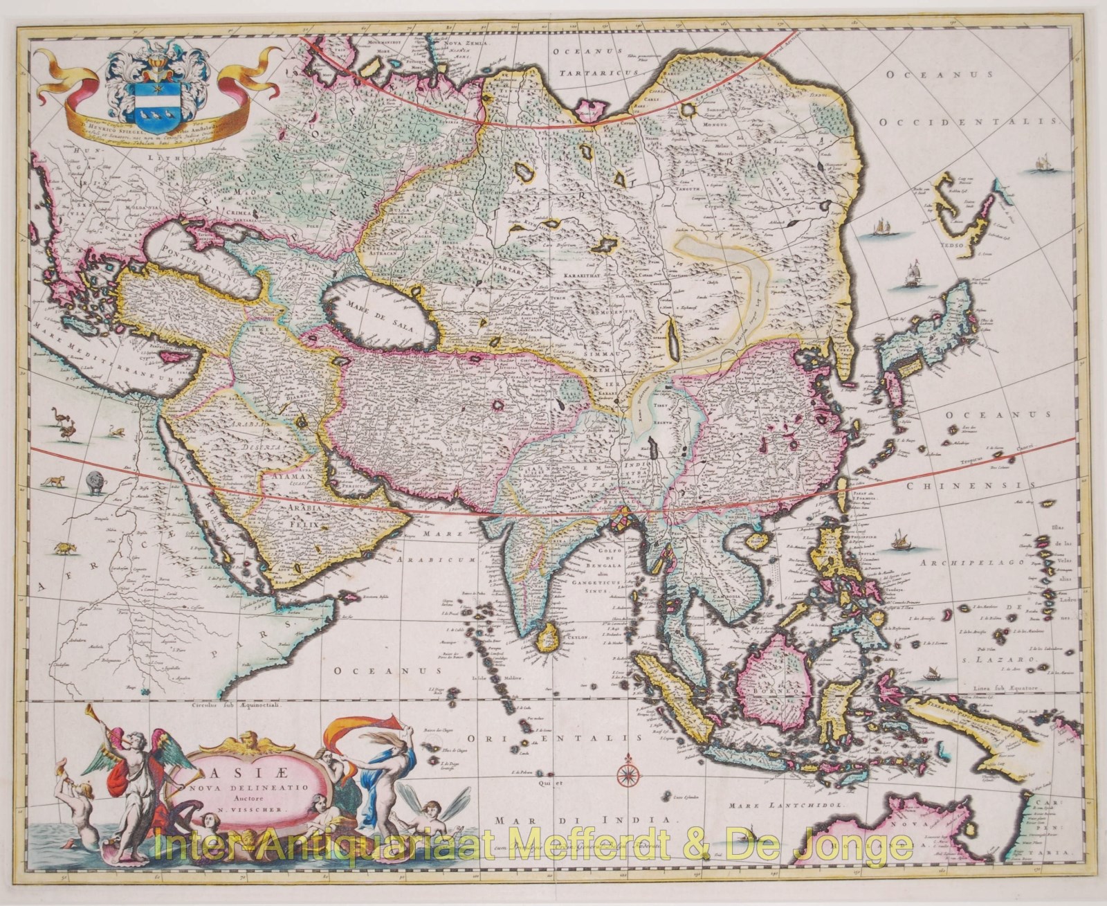
ASIA AND THE EAST INDIES – DECORATIVE MAP SHOWING DUTCH DISCOVERIES, C. 1680
“Asiae Nova Delineatio” [New Map of Asia], copper engraving published by Nicolaes Visscher I in Amsterdam, c. 1680. Original hand colouring. Size (map): 44.1 × 54.8 cm.
This decorative map depicts Asia and the East Indies in the second half of the seventeenth century, when Dutch explorers and merchants made important contributions to European geographical knowledge of the continent. The map extends from Eastern Europe, the Ottoman Empire and the Arabian Peninsula in the west, through Persia, India and China, to Japan in the east. To the south, it encompasses the vast Indonesian archipelago, the Philippines, New Guinea and parts of the northern coast of Australia.
Of particular interest is the depiction of Australia and New Guinea, incorporating the results of Dutch voyages of exploration undertaken by Willem Janszoon, Jan Carstenszoon and Abel Tasman. Along the lower edge of the map appear the then-known sections of the Australian coastline, identified as Hollandia Nova (New Holland) and Carpentaria. Large parts of the continent remained unknown to Europeans. The coastlines shown here reflect the important role played by the Dutch East India Company (VOC) in the exploration and mapping of these regions.
The depiction of Japan is equally remarkable. The outline of the main Japanese islands still largely follows the earlier cartographic tradition of Mercator and Hondius. To the north lies the separately depicted Yedso, a region now associated with Hokkaido and the neighbouring northern islands. This representation incorporates the discoveries of Maarten Gerritsz. de Vries, who explored the waters north of Japan on behalf of the VOC in 1643, charting the Kuril Islands and parts of Sakhalin. The uncertain shapes and positions of these landmasses illustrate how limited European geographical knowledge of Northeast Asia remained at the time.
China is represented in considerable detail, with numerous cities, rivers and mountain ranges. The Great Wall of China is also depicted. Particularly striking is the vast desert stretching across western China under the name Xamo, derived from the Chinese shamo (sandy desert). Lop, referring to the desert regions surrounding present-day Lop Nor, is also indicated.
The map is richly ornamented. In the lower left corner is an elaborate Baroque title cartouche, surrounded by sea nymphs, mythological figures and the winged goddess Fama, blowing her trumpet. In the upper left corner appears the coat of arms of Hendrik Spiegel, a prominent Amsterdam civic official who was also involved in the administration of the VOC. Visscher dedicated the map to him. The seas are enlivened with sailing ships and an elegant compass rose, while various exotic animals are depicted in the visible portion of Africa.
With its beautiful original colouring, wealth of geographical detail and exuberant decoration, this map is a characteristic example of the flourishing Amsterdam mapmaking industry of the seventeenth century. At the same time, it provides a fascinating record of Dutch voyages of exploration and the growing European knowledge of Asia, the East Indies and Australia.
Price: Euro 1.250,-