Skip to content
Inter AntiquariaatInter Antiquariaat
  • Menu
  • Home
  • About us
    • About us
    • Gifts
    • Selling to us
    • Terms of sale
    • Catalogues
    • Links
  • Events
  • Contact
  • Nederlands / English
  • Nederlands / English
  • City plans
    • Amsterdam
    • Rotterdam
    • The Hague
    • Other Dutch Cities
    • Foreign cities
  • City views
    • Amsterdam
    • Rotterdam
    • The Hague
    • Other Dutch Cities
    • Foreign city views
  • Maps
    • Maps The Netherlands
      • Brabant and Limburg
      • Central Netherlands
      • Groningen and Friesland
      • North Holland
      • South Holland and Zeeland
      • XVII Provinces/Dutch Republic
    • Maps World
      • Africa and Middle East
      • Asia
      • Europe
      • North- and South-America
      • World Maps
  • Various
    • Sir Lawrence Alma-Tadema
    • Various before 1880
    • Various after 1880
    • Maritime Prints and Drawings
    • Botanical prints and drawings
    • Dutch Winter and Skating Views
    • Fishes
  • Artists

Maps

Filter
  • 1
  • 2
  • 3
  • 4
  • 5
  • 6
  • 7

Showing 1–48 of 315 results

Our collection
  • Maps
    • Maps The Netherlands
      • Brabant and Limburg
      • Central Netherlands
      • Groningen and Friesland
      • North Holland
      • South Holland and Zeeland
      • XVII Provinces/Dutch Republic
    • Maps World
      • Africa and Middle East
      • Asia
      • Europe
      • North- and South-America
      • World Maps
  • City plans
    • Amsterdam
    • Foreign cities
    • Other Dutch Cities
    • Rotterdam
    • The Hague
  • City views
    • Amsterdam
    • Foreign city views
    • Other Dutch Cities
    • Rotterdam
    • The Hague
  • Various
    • Botanical prints and drawings
    • Dutch Winter and Skating Views
    • Fishes
    • Maritime Prints and Drawings
    • Various after 1880
    • Various before 1880
  • Sir Lawrence Alma-Tadema
  • Sold
's-Hertogenbosch - Willem en Joan Blaeu, 1634-1635Alternative view of 's-Hertogenbosch - Willem en Joan Blaeu, 1634-1635

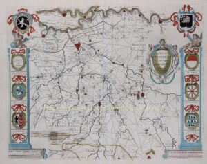
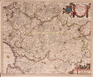
‘s-Hertogenbosch – Willem en Joan Blaeu, 1634-1635

€1.250
ABC islands (Leeward Antilles) - Joaquín Francisco Fidalgo, 1865Alternative view of ABC islands (Leeward Antilles) - Joaquín Francisco Fidalgo, 1865

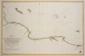
ABC islands (Leeward Antilles) – Joaquín Francisco Fidalgo, 1865

€1.450
Aceh War, Sumatra, Indonesia - J. Smulders & Co, 1873

Aceh War, Sumatra, Indonesia – J. Smulders & Co, 1873

€750
old map Achterhoek County of Zutphen Guelders historyAlternative view of Achterhoek (County of Zutphen) - Covens & Mortier, ca. 1720

Achterhoek (County of Zutphen) – Covens & Mortier, ca. 1720

€395
18e-eeuwse kaart van AfrikaAlternative view of Africa - Guillaume de L’Isle, Covens and Mortier, 1724

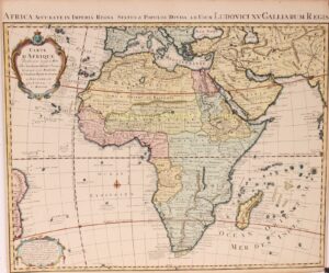
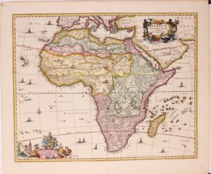
Africa – Guillaume de L’Isle, Covens and Mortier, 1724

€650
17e-eeuwse kaart van AfrikaAlternative view of Africa - Nicolaes Visscher, ca. 1677

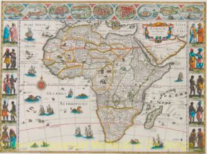
Africa – Nicolaes Visscher, ca. 1677

€1.650
Africa - Willem and Joan Bleau, c. 1640Alternative view of Africa - Willem and Joan Bleau, c. 1640

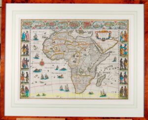
Africa – Willem and Joan Bleau, c. 1640

Ambon - Johannes van den Bosch, 1818

Ambon – Johannes van den Bosch, 1818

€625
America - Frederick de Wit, ca. 1680Alternative view of America - Frederick de Wit, ca. 1680

America – Frederick de Wit, ca. 1680

€1.650
America - Jodocus Hondius, 1606Alternative view of America - Jodocus Hondius, 1606

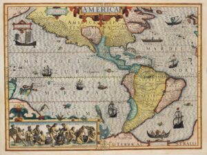
America – Jodocus Hondius, 1606

€4.950
America map - Ortelius

America map – Ortelius

€4.500
America, New England - Tobias Lotter, 1776

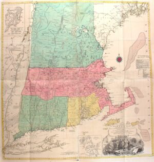
America, New England – Tobias Lotter, 1776

€5.500
American ports, West-Indies - Covens & Mortier, c. 1740

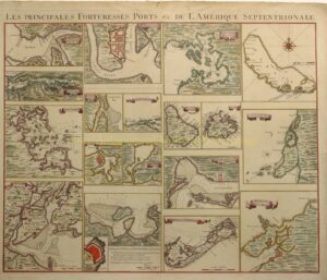
American ports, West-Indies – Covens & Mortier, c. 1740

€1.650
Americas, Caribbean sea chart - Theunis Jacobsz Lootsman, 1650

Americas, Caribbean sea chart – Theunis Jacobsz Lootsman, 1650

€1.450
kaart van 18e-eeuws AmstellandAlternative view of Amstelland - Gerrit Drogenham + Daniel Stoopendaal, c. 1720

Amstelland – Gerrit Drogenham + Daniel Stoopendaal, c. 1720

€5.850
18e-eeuwse hydrografische kaart van het IJ en de Zaan

Amsterdam, Zaandam – Von Wiebeking + Susemihl, 1798

€375
Angola, South Africa, Cape of Good Hope - Reinier & Josua Ottens, c. 1730Alternative view of Angola, South Africa, Cape of Good Hope - Reinier & Josua Ottens, c. 1730

Angola, South Africa, Cape of Good Hope – Reinier & Josua Ottens, c. 1730

€750
Arab world map ca. 1970Alternative view of Arab world map - Ibrahim al-Jaʿfarī, c. 1970

Arab world map – Ibrahim al-Jaʿfarī, c. 1970

€975
19th century map of Arabia, Gulf Arab StatesAlternative view of Arabia, Gulf Arab states - John Thomson, 1814

Arabia, Gulf Arab states – John Thomson, 1814

€495
old map of ArtoisAlternative view of Artois - Nicolaes Visscher, 1656-1677

Artois – Nicolaes Visscher, 1656-1677

€175
19e-eeuwse kaart van Aruba

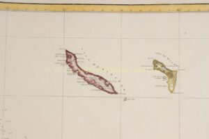
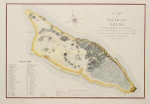
Aruba – Van Spengler + Van Raders, 1825

€2.150
Asia - Hendrik van Loon after Nicolas de Fer, 1724Alternative view of Asia - Hendrik van Loon after Nicolas de Fer, 1724

Asia – Hendrik van Loon after Nicolas de Fer, 1724

€14.500
Asia - Homann Heirs, 1744

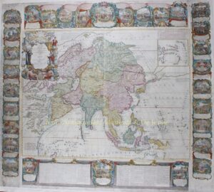
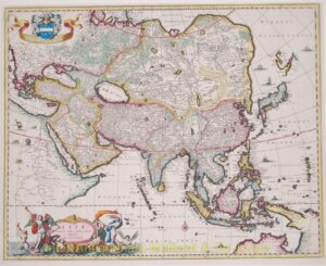
Asia – Homann Heirs, 1744

€625
17th century map of Asia by Jodocus HondiusAlternative view of Asia - Jan Jansson, 1638-1642

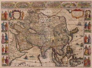
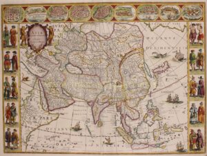
Asia – Jan Jansson, 1638-1642

€3.450
18th century wall map of AsiaAlternative view of Asia - Jean-Baptiste Crépy + Jean-Baptiste Nolin, 1781

Asia – Jean-Baptiste Crépy + Jean-Baptiste Nolin, 1781

€14.500
Asia - Jodocus Hondius, 1630-1631Alternative view of Asia - Jodocus Hondius, 1630-1631

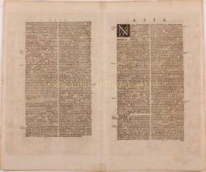
Asia – Jodocus Hondius, 1630-1631

€1.450
large 19th century map of AsiaAlternative view of Asia - L. Mertens + Theodore Lefevre, ca. 1870

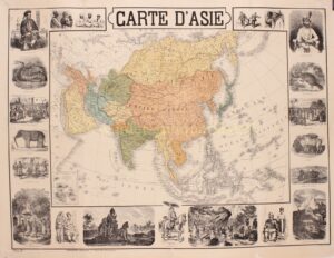
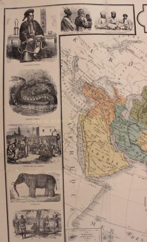
Asia – L. Mertens + Theodore Lefevre, ca. 1870

€1.450
antique 17th century map of Asia by Willem Blaeuantique 17th century map of Asia by Willem Blaeu

Asia – Willem Blaeu, 1621-1630

€3.450
Asia antique map - Visscher

Asia antique map – Visscher

€1.250
Admirality ChartAlternative view of Atlantic and Indian Oceans with the western portion of Pacific Ocean - UK Hydrographic Office, 1956 (1886)

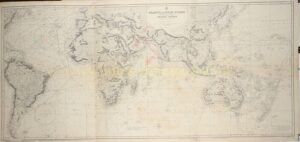
Atlantic and Indian Oceans with the western portion of Pacific Ocean – UK Hydrographic Office, 1956 (1886)

€450
Barbary, Egypt-Libya - Johannes van Keulen, 1681Alternative view of Barbary, Egypt-Libya - Johannes van Keulen, 1681

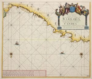
Barbary, Egypt-Libya – Johannes van Keulen, 1681

€375
Barbary, Libya - Johannes van Keulen, 1681Alternative view of Barbary, Libya - Johannes van Keulen, 1681

Barbary, Libya – Johannes van Keulen, 1681

€375
Batavia (Betuwe), Guelders - Joan Blaeu, 1660Alternative view of Batavia (Betuwe), Guelders - Joan Blaeu, 1660

Batavia (Betuwe), Guelders – Joan Blaeu, 1660

€1.350
Battle of the Slaak - Claes Jansz. Visscher, 1631Alternative view of Battle of the Slaak - Claes Jansz. Visscher, 1631

Battle of the Slaak – Claes Jansz. Visscher, 1631

€1.950
18e-eeuwse kaart van Beieren

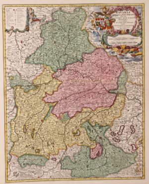
Bavaria (Bayern) – Nicolaes Visscher + Pieter Schenk, ca. 1720

€475
Bermuda - Willem Blaeu, c. 1630

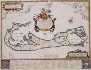
Bermuda – Willem Blaeu, c. 1630

€2.150
Borneo - François Valentijn, 1724-1726

Borneo – François Valentijn, 1724-1726

€950
16e-eeuwse kaart van Brabant, kopergravure uitgegeven door Abraham OrteliusAlternative view of Brabant - Abraham Ortelius, 1595

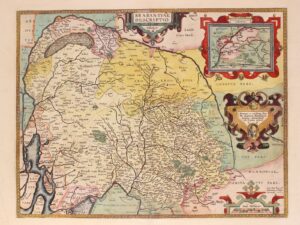
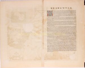
Brabant – Abraham Ortelius, 1595

€875
17th century map of the duchy of Brabant published by Willem BlaeuAlternative view of Brabant - Willem Blaeu, 1635

Brabant – Willem Blaeu, 1635

€750
Brabant - Willem Blaeu, ca. 1650

Brabant – Willem Blaeu, ca. 1650

€375
Brabant, Baronie van Breda - Nicolaes Visscher, c. 1680

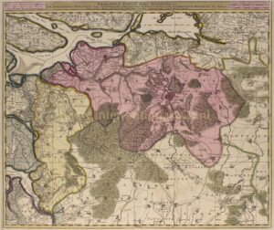
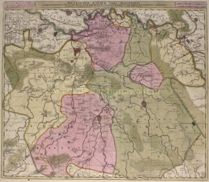
Brabant, Baronie van Breda – Nicolaes Visscher, c. 1680

€550
17th century map of the Margraviate of Antwerp published by Willem BlaeuAlternative view of Brabant, Margraviate of Antwerp - Willem Blaeu, 1635

Brabant, Margraviate of Antwerp – Willem Blaeu, 1635

€425
Brabant, Meierij of 's-Hertogenbosch - Nicolaes Visscher, c. 1680

Brabant, Meierij of ‘s-Hertogenbosch – Nicolaes Visscher, c. 1680

€550
18th century map of Brandenburg-PruissiaAlternative view of Brandenburg-Prussia - Peter Schenk, c. 1720

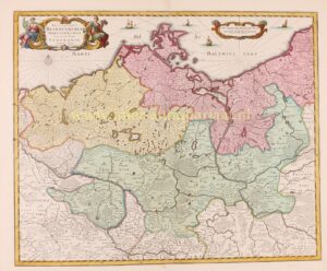
Brandenburg-Prussia – Peter Schenk, c. 1720

€575
17th century map of the British Isles dedicated to King William IIIAlternative view of British Isles - Nicolaes Visscher, c. 1690

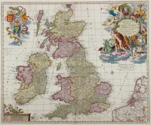
British Isles – Nicolaes Visscher, c. 1690

€950
17th century Heptarchy Map - British IslesAlternative view of British Isles - Willem Blaeu, c. 1645

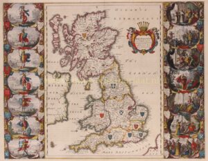
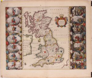
British Isles – Willem Blaeu, c. 1645

€1.650
Brittenburg (Leiden and surroundings) - François van Bleyswijck, 1734

Brittenburg (Leiden and surroundings) – François van Bleyswijck, 1734

€175
antique Canada map original 18th century engravingAlternative view of Canada - Guillaume De L'Isle, Covens & Mortier, c. 1730

Canada – Guillaume De L’Isle, Covens & Mortier, c. 1730

€1.450
  • 1
  • 2
  • 3
  • 4
  • 5
  • 6
  • 7
We are member of
nvva
Dutch Association of Antiquarian Booksellers
 
ilab
International Antiquarian Booksellers Association
 
kvhok
Royal Association of Fine Art Dealers in The Netherlands
 
cinoa
International Confederation of Art and Antique Dealers Associations
We accept:
© 2024 Inter-antiquariaat Mefferdt & De Jonge | Bernard Zweerskade 18 | NL-1077 TZ Amsterdam | The Netherlands | T +31 - (0)20 - 66 40 841
  • Bekijk site in het Nederlands
  • City plans
    • Amsterdam
    • Rotterdam
    • The Hague
    • Other Dutch Cities
    • Foreign cities
  • City views
    • Amsterdam
    • Rotterdam
    • The Hague
    • Other Dutch Cities
    • Foreign city views
  • Maps
    • Maps The Netherlands
      • Brabant and Limburg
      • Central Netherlands
      • Groningen and Friesland
      • North Holland
      • South Holland and Zeeland
      • XVII Provinces/Dutch Republic
    • Maps World
      • Africa and Middle East
      • Asia
      • Europe
      • North- and South-America
      • World Maps
  • Various
    • Sir Lawrence Alma-Tadema
    • Various before 1880
    • Various after 1880
    • Maritime Prints and Drawings
    • Botanical prints and drawings
    • Dutch Winter and Skating Views
    • Fishes
  • Artists
  • Home
  • About us
    • About us
    • Gifts
    • Selling to us
    • Terms of sale
    • Catalogues
    • Links
  • Events
  • Contact